DETECTION OF COASTAL MARINE LITTER USING DRONE DATA COMBINED WITH THE APPLICATION OF MACHINE LEARNING METHODS
TECHNOLOGY
cross-sectoral
plastic pollution reduction and others

Monitoring and Control
Solution Scope: Monitoring & Tracking Technologies (Aerial drones)
Target Contaminant: Plastics & Other Litter (Beach litter)
Solution Provider or Contact Point: SciDrones
Project: CMLO – Coastal Marine Litter Observatory
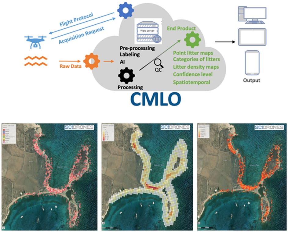
ITS Description: The Coastal Marine Litter Observatory (CMLO) is a platform which detects, maps and monitors marine litter in the coastal zone with the combined use of Unmanned Aerial Systems (UAS) and machine learning. The results presented through CMLO are open through a dedicated geospatial portal. In the CMLO system, the detection of marine debris in the coastal zone is visualized as density maps. The system provides functionalities for interaction with the results of the detection for every beach that is monitored. The methodology involves utilizing UAS to capture high-resolution aerial photographs in accordance with the SciDrones flight protocol. These images are then processed using machine learning algorithms to identify and map marine litter. The outcome of this process is the creation of density maps that display the distribution of marine litter in the coastal zone. Additionally, the CMLO system is capable of detecting and categorizing seven different types of marine litter, including plastic, paper, metal, cloth, glass & ceramic, rubber, and wood. The resulting classification data is presented in the form of density maps, which utilize a 10×10 meter grid and adhere to standardized EU visualization methods. These maps provide a visual representation of the number of litter tiles per 100 square meters, effectively illustrating the density of litter within the designated area. CMLO includes all the derived information as geospatial information related to 1. Densities of plastic litter on various beaches across the world; 2. Plastic waste density maps per area of interest; and 3. Spatiotemporal visualizations of plastic litter per area of interest This ITS is a valuable resource for displaying the distribution of marine litter in coastal areas through automated classification techniques. Through the CMLO application, users have the ability to interact and compare the results of marine litter detection on each monitored beach. This tool, along with the produced density maps, can aid policymakers and scientists in making informed decisions.
Correspondence with BMM OIR (sectoral priorities, R&I activities, gaps, needs): The ITS responds to a R&I focus area of activities alongside the monitoring & control dimension, particularly through the development of new tech-based monitoring technologies via satellite imaging. Furthermore, the solution addresses several sectors and priorities of the BMM OIR, e.g. the technological challenges of the BMM OIR forthe Wastewater and Solid Waste Management Sectors. Most prominently, it improves monitoring and assessment strategies to address current and emerging pollution, particularly through improving analytic capabilities through modern technologies.


